Category: Historic landscapes


Municipal Dreams's avatarMunicipal Dreams

Balfron Tower is now one of the stately homes of England – a National Trust attraction no less.  Recently it’s hosted an arts season, a Shakespeare play, and it’s provided live-work accommodation for twenty-five artists since 2008.  And all that, to be honest, makes me sad because once Balfron was simply housing for the local people who needed it – although its size and style and big name architect did always get it special attention.

Photograph taken in 1969 showing original concrete chimneys to service tower boilers (from Brownfield Estate, Poplar Conservation Management Plan) 
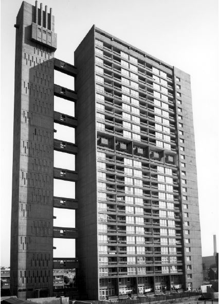
Photograph taken in 1969 showing original concrete chimneys to service tower boilers (from LBTH, Brownfield Estate, Poplar Conservation Management Plan)

The site for what is currently the Brownfield Estate, in which Balfron is located, had been identified as early as 1951.  The now truncated St Leonard’s Road was one of Poplar’s principal streets; the area as a whole comprised a dense grid of old and substandard terraced housing.  The land was acquired in 1959 just as…

View original post 1,118 more words

IMG_0182

It was our second full day. We left home along mountain tracks and soon found our way onto one of the very good motorways here. I guess it took us a little over an hour to reach our destination for the day, Granada. Deborah and I had been here before, some 9 years ago, visiting our daughter who was studying at the University. I was excited about returning, especially to see the Alhambra, which was one of the experiences that turned me on to garden design.

We spent the morning and early afternoon walking the streets. Oh, and took a rather disappointing open-topped bus ride of the city, which we’d done before, but this time it seemed to be a stagger from one traffic light to the next, amidst heavy traffic and which, I guess, lacked the novelty of that first trip. Still, a nice coffee in the precincts of the cathedral and a wander around the moorish quarter, including a wonderful lunch in a restaurant overlooking the Alhambra, all made for a good start to the day.

The afternoon began with the ascent to the main entrance to the Alhambra, where pre booked tickets are essential as the place gets very busy and you need to have a time slot for the most famous bit, the Nasrid Palace. Ours was for late afternoon so we had a few hours to take in the Generalife (the adjacent palace) and the rest of the Alhambra before the real treat. I seem to remember we didn’t get much of a look around the Generalife 9 years before, so today we began there and it was well worth spending more time amongst its wonderful gardens. Here are a few pictures…

This slideshow requires JavaScript.

We wove our way through crowds towards the Alhambra and made it up to the castellated viewpoint of the Alcazaba, just in time to get to our allotted spot at the nearby Nasrid Palace. This consists of a series of interlocking rooms, chambers and courtyards or patios. It was worth the preamble.

As you enter the Palace you plunge into a room of near darkness, only to emerge into the dazzling light of the outside space. I’d forgotten how simple, peaceful and mystical the Patio of the Myrtles was, with its sheet of water and simple structural planting. I sat and took in the scene, which was rather like an outdoor cathedral- you know, even though there are people around and making noise, the space seems to dissipate and soften that so that it forms a sort of background murmur, almost of reverence?

The slow trickle of water from a fountain added to the ambience, quite a contrast to the rushing of the arched fountains in the Generalife (I’ll post a couple of videos comparing them in the next day or two). Here are some pictures of the outer Alhambra and the Nasrid Palace…

This slideshow requires JavaScript.

The moorish ornamentation of the rooms and external walls is breathtaking in its complexity, but there is an overall harmony. The light is used cleverly to provide alternating experiences of rich, internal splendour and simpler, but equally impressive outside spaces. The Patio of the Lions was altogether grander and more ornamental in style, the sort of space you can imagine political deals being concluded under the loggia, perhaps having spent time meditating on these in the previous patio? From there we gradually ‘came down’ through simple, lush outside spaces which are more expansive, but still attractive; blocks of colourful planting beginning to re-engage you with the outside world of colour and noise.

Well, I got my ‘fix’. Our drive home was a little more eventful than our outward one, as we had both darkness and rain to contend with. But we rolled safely into the Cortijo and managed a late night supper (I think it must have been 11pm before we ate) round the pool. A quieter day tomorrow, perhaps?

Further information: Granada- Wikipedia

Old School Gardener

WP_20140916_13_06_39_Pro

It was late September and we had travelled to Spain for a week’s break in a farmhouse home in a remote mountainous region of innner Andalucia. Having settled in, done our first food shop and enjoyed our first evening meal by the pool we decided to make a short trip out on our first full day to the nearby village and lake of Iznajar.

Felicty enjoying our lunchtime view
Felicity enjoying our lunchtime view

Andalucia.com describes the village and area:

‘This small town of some six thousand inhabitants was transformed some years ago by the creation of an ’embalse’, or reservoir, below the promontory on which Iznajar sits in the River Genil valley. Today, to all intents and purposes, Iznajar now has a waterfront, overlooking an inland sea some thirty kilometres long, and containing an estimated 900 million cubic metres of water destined for domestic consumption…

Iznajar itself escaped the submersion that often visits towns and villages in the region of Andalucía’s controversial programme to construct more and more dams and reservoirs to serve this increasingly thirsty region. If anything, the lake below has given further resonance to its unofficial title as the Mirador (viewpoint) del Genil. Surrounding countryside and communications have been radically altered, not least by a bridge built across the reservoir near Iznajar in order to continue to carry traffic on the Archidona/Priego de Córdoba road…

The village was originally a prehistoric Iberian settlement, but flourished in the eighth century when Arab settlers, in the wake of the 711AD invasion by Tariq ibn Zayid and his Moorish armies, built a castle on the promontory and called it ‘Hins Ashar’ (hence the modern Spanish name). It became the focus of battles between various north African factions, finally being taken by the army of Abderramán III. After the fall of the Caliphate of Córdoba, then the capital of Al-Andalus, it fell under the rule of the dependency of Granada. In 1431, in the reign of Catholic monarch Juan II, it was taken back by the Christian rulers, some sixty years before Granada was to fall in 1492. Iznajar gained brief notoriety in 1861 when the town supported an uprising against the monarchy, led by Rafael Perez del Alamo, with grimly predictable consequences…

The ruins of the 1,200-year-old castle are the obvious key attraction for the visitor… Parts of the fortified town walls can also be seen in the upper reaches of the town. Inside the town walls, a small square called the Patio de las Comedias suggests that, despite its defensive position, Iznajar once had a theatre culture that probably tracks back millennia… the Iglesia de Santiago church, (was) built over time during the fifteenth and sixteenth centuries, with a remarkable late addition in the form of a Baroque altar piece. The cemetery next to the church only dates back to 1806…

The most interesting barrio, district, of Iznajar is the Barrio del Coso, a labyrinth of typical whitewashed Andalucían houses dotted around a labyrinth of narrow lanes that criss-cross the promontory. As if often the case in these hill towns, the ‘lower’ part is also the newer part of town…..’

This slideshow requires JavaScript.

I loved the majestic setting of this lovely village and the obvious care the residents take in looking after their private and public spaces. Having ‘mooched’ around the village in the morning and had a light tapas lunch with a splendid balcony view across the village, we moved off to the nearby ‘beach’, where we had the place almost to ourselves (that’s wife Deborah and friends Nick and Felicity). The beautiful setting, warm sunshine and water (I actually swam!) made for a relaxing beginning to our week’s adventure…

Old School Gardener

Pew Tor- an old friend

Our final walk. We returned to an old favourite, Pew Tor, just a short drive from Tavistock. It has a wonderful rock formation, remiding me of a dog’s head (see the picture above). It’s an old favourite because this walk has become bit of an institution in our family. We have done it many times with our children at various times in the past. Perhaps the most memorable occasion was when our, then young, son raced back down the slope with the call ‘running down the mountain, with some shouting!’

This slideshow requires JavaScript.

The walk today, another sunny afternoon, was easy. On previous occasions it has been a bit of a puff, but I guess our training on the previous five days was enough to make it a breeze. But this time something else was different. On previous occasions I’d looked around at the views and not known many, if any of the other tors and land in view.

But today, this felt like my space– I don’t know if it was the euphoria of having walked 20 tors in six days, or more the fact that I could look around, name the tors we could see, and more significantly, say we went there on…..

Water action has created a pool in one of the Tor's top stones

Water action has created a pool in one of the Tor’s top stones

We’ll be back- maybe for another 20 of the 160 plus tors, so that we can gradually come to know this wonderful moor even better.

Old School Gardener


WP_20140905_019

Day five on our Tor Challenge involved heading out towards Princetown once more. Our start point was a small car park near to one of the tors we would be visiting and which is also home to a tall TV mast- north Hessary. A little cloudier than previous days but still dry and warm, so it looked like it was going to be a pleasant afternoon walk. and what’s more, we were aiming to cover 6 tors, which would bring us within reach of a total of 20 for the week.

As we set off we noticed an elderly couple just heading off in the same direction as us – towards Hollow Tor, and from here to the fairly indistinct Rundlestone Tor.

Hollow Tor

Hollow Tor

From there it was short walk long a road to the TV station and tor at north Hessary, the mast of which you can see for miles around, but which despite many years visiting the area I had never got close to. The mast is an impressive, albeit man- made intrusion in the landscape. The tor itself is rather tangled with the mast and surrounding walls and fencing, but is nevertheless and distinctive shape. I also found a small plastic box containing a stamp and notebook (see picture at the head of this article), an effort by a couple of local youngsters to place a ‘post box’ for visitors to leave a message and read those put by earlier visitors. It was a modern-day example of the Dartmoor Post Boxes, I suppose an earlier form of ‘Geocaching’:

‘A small pot (the letterbox) containing a stamp and visitors’ book is hidden on the moor, and a clue is written to lead others to its position. Clues may be as simple as a map reference and list of compass bearings, or may be more cryptic.

When a letterbox is found, the letterboxer takes a copy of the stamp, as well as leaving their own personal print in the visitors’ book.

Letterboxing began on Dartmoor but is now popular in areas all over the world.’ (source: Dartmoor letterboxing.org)

Travellers from Muenster, Germany logged into the 'post box' on north Hessary

Travellers from Muenster, Germany logged into the ‘post box’ on north Hessary

Taking a bearing to our next tor, ‘Foggintor’, we set off, but a little wary, because we had a walk guide which suggested that Foggintor was in fact an old quarry and one which you come across suddenly – beware 100 foot drops! We trudged down and then up bracken-strewn valley sides, heading for a group of rocks on the horizon which the bearing suggested was our target. We reached the edge of what looked like an old quarry but somehow the map and what we saw weren’t the same; where were we?

We pressed on thinking the rocks in front were what we were looking for and then looked back – in the distance and to the left of the route we’d taken, was an obvious old quarry with some apparently deep sides. We’d obviously not been accurate in our bearings and missed the quarry (I was sort of relieved, given the look of it). This is a ‘tor no more’, as the quarrying seems to have removed all evidence of the sort of rocks or peak that we’d come to expect.

Foggintor- quarrying has removed the tor?

Foggintor- quarry has removed what was there?

 So, we were actually standing next to our fourth tor target of the walk, Swelltor, also an old quarry, but with a more discernible peak and tor like appearance.

Swelltor- more quarrying

Swelltor- more quarrying

 From here it was a simple, fairly level walk across moor to our final target of the day, King’s Tor, which had some remarkable rock piles- see the pictures below.

This slideshow requires JavaScript.

The views from King’s Tor were also good, though a mist lay over the horizon so we couldn’t see as far as had been possible earlier in the week. We looked across the valley to Yellowmeade Farm, which gave us our target for the return walk to the car. This looked to be straight, fairly short walk, but the map and walk guide advised that it would be marshy ground, so wer were prepared for wet feet! But apart from a few soggy areas, the lack of any heavy rain for a week seemed to dry out the peaty conditions underfoot, so it was more a case of hopping form grassy clump to grassy clump than wading through water!

So that was it, we got back to the car only to arrive at the exact moment the elderly coupe we’d seen early did too! They were over for the weekend from Somerset and were looking for letterboxes and had apparently found quite a few.

The day had brought 6 more tors (well nearly if you count our skirting of the tor no more) and we looked forwards to our last day, when we would climb an old favourite and bring our tally up to 20 tors.

Old School Gardener

WP_20140904_021

Day Four involved a figure of eight walk with a starting pont at the cross over of the 8. This was still a relatively short walk and would enable us to visit four tors; Leather Tor, Sharpitor, Leeden Tor and Ingra Tor. Our start point was a car park between Yelverton and Princetown, so once more we returned to southern Dartmoor.


Sharpitor

Sharpitor

We were again blessed with bright sunshine. From our start it was a bit of a puff walk up the northern slope of Sharpitor, a tor with lots of broken boulders and some interesting features.

Leather Tor

Leather Tor

From here it was a short walk across to the more impressive ‘peak’ of Leather Tor, which looked rather more like a mountain climb than was eventually required, but it was nonetheless great to clamber over rocks and stretch the tendons! After a short walk back to the car around the edge of Peek Hill, we paused for refreshments. Off again, this time we headed to the north and Leeden Tor, though our reliance on map reading and not the bearings we had planned proved to take us off the most direct route.

This slideshow requires JavaScript.

Having rechecked our bearings and double checked our map we set off for Ingra Tor, a very interesting, longish rock formation with some interesting shapes and wonderful views to the southern moor and small farms. I think this was one of my favourite tors and I took a souvenir piece of granite from it for a paperweight.

Ingra Tor - one of my favourites

Ingra Tor – one of my favourites

Four more tors completed, taking our tally to 13 for the four days. The weather was holding and it looked like we would easily exceed our challenge of climbing 10. Day five brought some interesting new angles on the tors, including one that no longer exists!

Old School Gardener

WP_20140903_018This was the big one. Day three of our Tor Challenge was billed as an all dayer, packed lunch required. Travelling to the northern edge of Dartmoor at Meldon, near Okehampton, we headed for the reservoir, a beautiful site in itself and the starting point for our day’s walk.


It was a long trudge around Longstone Hill and then across valleys and into the (today quiet) firing range, towards Black Down. From  here we followed increasingly rugged and harder-to- see paths to the foot of West Mill Tor. A short, steep ascent was rewarded with a tremendous view on another beautifully sunny day. From  here we could see our ultimate objectives- High Willhays (the highest  point in Devon and southern England) and Yes Tor, slightly lower. It was also from here that we made our first spotting of…….a nude walker! At least that’s what it looked like as a well-tanned male torso was seen stepping out boldly towards the slopes of Yes Tor. Having got over the ‘shock’ of this sight we made our way down to a wide, well trodden path that would take us up to the ridge between the two tors we were left with.

This slideshow requires JavaScript.

This was steady walking, remembering to pick up a stone or two en route to add to the cairn atop High Willhays. It was here that we saw our nude friend once more, striding out but also rather aimlessly- was he looking for someone to show off to? (we didn’t get close enough to see if he had reason to show off…). Or was he following us? He seemed to be close to our route across to Yes Tor and even waved at me and said ‘Hi’ just after I snapped a picture to prove our point….

Back to Nature- 1

Back to Nature- 1

Back to Nature- 2....

Back to Nature- 2….

After a packed lunch atop Yes Tor, admiring the distant views and chatting to fellow walkers, we saw some low clouds forming to the south and so decided to pick our way back to Black Down the quick route down the slopes, but also a rather wetter one through boggy ground. So, that’s nine Tors done, how many more could we add?

Would Day Four live up to this latest experience?

Old School Gardener

The view in the morning - looking towards Tavistock from the car park near Merrivale

The view in the morning – looking towards Tavistock from the car park near Merrivale

Having seen off the rain and mist on the first day of our ‘Tor Challenge’, we started day two with bright sunshine- you could see across the moor for miles. Today’s plan was to do two walks with a break for lunch at a well-known pub (the ‘Dartmoor Inn’ at Merrivale). The morning began with a couple of hours walk close to where we were on day one, but the contrast in weather couldn’t have been starker.

Having parked up at the pub we set off following the road back towards Tavistock and then headed inland (having taken a bearing first) ascending and crossing the rounded crest of Barn hill to the first of the targets, Feather Tor, an unassuming tor from it’s approach, but with some interesting rock formations (and a rare Dartmoor tree!).

From here it was a short, but steep walk up to a much more expansive tor, Heckwood. It affords a view that is truly breathtaking and I think this, on reflection, was one of my favourite tors on our challenge. The walk back to the pub involved finding a stream and following this past Vixen tor (which is a striking formation, but unfortunately not accessible to the public), and involved some boggy ground, but nothing too uncomfortable despite the previous day’s rain.

This slideshow requires JavaScript.

Lunch was a perfect combination of  ‘Pannini and Pint’, after which we drove to our afternoon walk- north of Tavisotck, near Lydford this time and involving one tor I’d walked a good few years back, Brat Tor with the famous stone Widgery Cross at its summit. This was quite a climb, but again, a combination of walking poles, good boots and light clothing made it only partly puffing!

The cross was erected to commemorate the Golden Jubilee of Queen Victoria in 1887. It measures 12 feet 8 inches (3.86 metres) tall and 4 feet 4 inches (1.32 metres) across the arms. The shaft is 2 feet 1 inch (0.64 metres) square and is made of 10 layers of roughly cut granite blocks, topped off with a pointed rock. The blocks are of differing sizes, which interlock with each other to make the structure more secure. It was erected at the expense of William Widgery, the well-known local artist, and bears the inscription: ‘W. Widgery, Fecit, Jubilee, V.R.’

This slideshow requires JavaScript.

From here we walked across a valley to Arms Tor (not sure if it’s called that because it has two distinctive blocks that look like arms?), which stands about 6 metres higher than Brat Tor at 457 metres.

From here, in the warm afternoon sunshine, we made our way back to the bridge and stepping stones over the River Lyd where I recorded a short video to capture the magical sound of the rippling water…..

The end of a marvellous second day and meanign we had already completed 6 tors in our Tor Challenge! Day three was to prove a bit of an eye opener in several ways…..

Old School Gardener

What a pile- some amazing granite on Great Mis tor

What a pile- some amazing granite on Great Mis tor

So, the first day of our recent ‘Tor Challenge’  began. It wasn’t promising- showers and low cloud hung over Tavistock for most of the morning and into early afternoon. But, as forecast, it lifted and was dry enough to venture out by about 4pm.

My wife had spent a lot of time researching our various walks and calculating distances, heights, grid references and bearings. we were well equipped with some new waterproofs, boots, walking pole and downloaded app for my phone (which gives a grid reference for your position and, if needed, a marker on a base map). We had looked into buying a GPS device for walking, but on balance, we felt this wouldn’t be necessary for the lengths and routes we’d gone for and with my new phone app (alongside other useful apps).

We’re not the sort of people to accept new things without question, and when it comes to clothing we’re definitely favour ‘natural’ materials over man made. However, I couldn’t resist buying a synthetic ‘base layer’ shirt in a sale we’d seen a week or two before and today was it’s first outing , under my new ‘waterproof and breathable’ jacket. I was im pressed with both, as you’ll see.

Any way, we set out for what promised to be a short walk to twowell-known tors – Great and Little Mis tors, lying just to the north-east of Princetown (of Dartmoor Prison fame) and within the Merrivale firing range (we’d checked and no firing was planned). According to Philip Henry Gosse (in his book ‘Land and Sea’, 1865), the name ‘Mis’ may derive from the tors’ druidical connections, being named after Misor the British moon goddess!

The way up- and the cloud/mist descends....

The way up- and the cloud/mist descends….

The ascent was long and reasonably steep from the car park (170 metres in fact to the summit of Great Mis tor, which is 538 metres above sea level). As we ascended we saw the low cloud covering the top of the climb and were prepared for our first taste of ‘blind walking’. We needn’t have worried. a well- worn path took us most of the way to Little Mis tor, and after a quick check on my new phone app, we knew we must have been just a few steps away from  Little Mis Tor- which we couldn’t see for all the cloud/mist. sure enough stepping out in what we thought to be the right direction, it suddenly loomed up before us- I thought it was a tree at first but it’s rocky outline was soon clear.

From here, once climbing the short route to its summit, it was short walk across open ground (following the pre-plotted bearing) to the tor’s bigger brother (or sister), Great Mis tor. this has been called ‘one of the grandest hills in Devon’ and is one of the largest tors in the southern moor, but today our view to it and form it was a complete fog, so we’ll have to return another day to appreciate the glorious view.

Great Mis Tor- the fortress looms up...

Great Mis Tor- the fortress looms up…

As we approached the tor (or so we thought) two walkers emerged from the mist walking towards us and we confirmed that we were on the right track. And a few steps further on there it was, certainly a more impressive ‘pile’ than its little sibling, and standing rather like some medieval fortress awaiting an attack- especially with its flagpole which is used to indicate if the firing raneg is beign used. We scaled it without a problem and peered around the immediate area as far as the mist would allow- not very far at all. Having climbed our first two tors, there wasn’t much else to do, so we returned.

Following my fortress analogy, coming down a different route still, at first, covered in mist and so focused on our immediate terrain (a large area of fallen granite boulders), felt rather like stepping on and over the bodies of fallen warriors, whose attack on the citadel above had obviously failed. It was eerily quiet and still with no hint of a breeze, and the clammy wetness stuck to our faces and clothes.

Reaching the bottom – and a clear sky once more- was a minor relief and boosted our confidence about our preparedness for the more challenging tors to come. A good start then. and I must say a comfortable experience too, as my new ‘base layer’ and waterproof had kept me warm and dry (inside as well as out) and my new boots were proving to be the dream footwear I had expected. We may not have given this new stuff much of a test, but it was the perfect primer for the days to come, which the weather forecast predicted would be dry, and mostly clear and warm.

The forecast turned out to be correct and the rest of our week enabled us to not only experience the climbing and walking to our tor targets for the day, but to soak up the scale and beauty of the Dartmoor landscape…as you’ll see if you join me for my next instalment of our tor challenge!

Day 2 beckons….

Old School Gardener


WP_20140903_020We’re just back from a week in Dartmoor, Devon, walking between some of the well-known, usually prominent rocky features of this beautiful landscape, known as tors

The Challenge

The tors (there are over 160 of them) are the focus of an annual event known as the Ten Tors Challenge, when around 2400 people aged between 14 and 19 (in over four hundred teams of six), face hikes of 35, 45 or 55 miles (56, 72 or 88km) visiting ten nominated tors over two days.  The teams must be self-sufficient, carrying all that they need to complete their route safely despite the terrain and the weather.  The latter can be very changeable and at times quite extreme, and success or failure can depend very much on the extent to which a team has been trained for all eventualities.

Not having completed this in her youth, my partner ( a local lass), was keen to do her own ‘Ten Tors Challenge’, but at a more leisurely pace. In the event, extremely good weather meant that we were able to visit double the target number of tors spread over six days, and including excellent overnight accommodation at my mother – in – law’s house in Tavistock! Over a series of posts in the next few days, I hope to give an interesting account of our adventures along with a few pictures. For starters here’s a ‘primer’ on Dartmoor and the tors in question….

dartmoor locationThe Moor

Covering an area of 954 sq km (368 sq miles), Dartmoor contains the largest and wildest area of open country in the south of England. By virtue of its outstanding natural beauty it is one of the National Parks of England and Wales. Unlike many National Parks in other countries, for example the USA, the National Parks in England, Wales and Scotland are not owned by the state.  The term ‘National’ means that they have been identified as being of importance to our national heritage and as such are worthy of special protection and attention.  Within each National Park there are many landowners, including public bodies and private individuals. National Parks are places where people live and work.

Geology

A large part of Dartmoor (65%) is made up of granite, an igneous rock which was intruded some 295 million years ago.  This great granite core is surrounded by sedimentary rocks including limestones, shales and sandstones belonging to the Carboniferous and Devonian periods.  Those nearest the granite intrusion were altered (metamorphosed) by intense heat and pressure and chemical reactions.

Tors

Dartmoor is known for its tors – hills topped with outcrops of bedrock, which in granite country such as this are usually rounded boulder-like formations. More than 160 of the hills of Dartmoor have the word tor in their name but quite a number do not.   However this does not appear to relate to whether or not there is an outcrop of rock on their summit.

The processes resulting in the formation of the Dartmoor tors started about 280 million years ago as the granite forming Dartmoor cooled and solidified from molten rock at a temperature of 900 – 1000˚C. The minerals which make up granite crystallised as closely interlocking grains forming the hard rock. Granite is formed of three main minerals: Quartz – appearing in the granite as translucent slightly greyish looking grains; Feldspar – white grains, sometimes stained yellowish or pink (in parts of the granite feldspar forms large white crystals); and Biotite – dark brown glistening flakes.

dartmoorVarying climatic conditions occurring over millions of years, along with the cooling of the molten and other materials were the first, mainly chemical factors in the formation of the tors. Most recently, cold conditions in the Ice Age (between 2 million to 10,000 years ago), have caused major mechanical forces to shape the landscape we see today. Of these the most important is the expansion of freezing water. The deeply weathered granite was forced apart and broken up into blocks by being subjected to frequent freezing and thawing during the cold periods of the Ice Age, and gravity was also important, moving the loose material downhill.

 The principal tors are:

Tor Height above sea level
High Willhays 621m (2,039ft)
Yes Tor 619m (2,030ft)
Great Links Tor 586m (1,924ft)
Fur Tor 572m (1,876ft)
Great Mis Tor 539m (1,768ft)
Great Staple Tor 455m (1,493ft)
Haytor 454m (1,490ft)
Hound Tor 448m (1,469ft)
Sharpitor 402m (1,320ft)
Sheeps Tor 320m (1,050ft)
Vixen Tor 320m (1,050ft)

Well that’s the basics….except you might be interested in a TV programme that is showing this evening (Tuesday 9th September) on ITV 1 (7.30pm). The first in a new series of ‘Wilderness Walks’ by bushcraft expert Ray Mears focuses on Dartmoor. I’ll certainly be watching….

…so now for an article on the first stage of our trip – and it’s a mysterious beginning to our adventure that awaits…..(I’ll explain more about the nudist along the way too).

Further Information:  Dartmoor National Park

Old School Gardener

Finding Nature

Nature Connectedness Research Blog by Prof. Miles Richardson

Norfolk Green Care Network

Connecting People with Nature

Discover WordPress

A daily selection of the best content published on WordPress, collected for you by humans who love to read.

Susan Rushton

Celebrating gardens, photography and a creative life

Unlocking Landscapes

Writing, photography and more by Daniel Greenwood

Alphabet Ravine

Lydia Rae Bush Poetry

TIME GENTS

Australian Pub Project, Established 2013

Vanha Talo Suomi

The Journey from Finnish Rintamamiestalo to Arboretum & Gardens

Marigolds and Gin

Because even in chaos, there’s always gin and a good story …

Bits & Tidbits

RANDOM BITS & MORE TIDBITS

Rambling in the Garden

.....and nurturing my soul

The Interpretation Game

Cultural Heritage and the Digital Economy

pbmGarden

Sense of place, purpose, rejuvenation and joy

SISSINGHURST GARDEN

Notes from the Gardeners...

Deep Green Permaculture

Connecting People to Nature, Empowering People to Live Sustainably

BloominBootiful

A girl and her garden :)